| ROUTE 1: Intxorta
ROUTE 2: Gaztelumendi ROUTE 3: Asensiomendi ROUTE 4: Swamp Aixola ROUTE 5: Erdella Route 6: Goikomendi ROUTE 7: Azkonebieta Route 8: Egorbitza ROUTE 9: Santa Marina Zar |
AZKONEBIETA

|
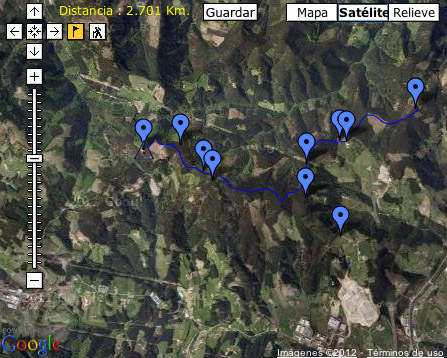
Mendiak Elgetako Summit, east of the port Karabieta (558 m) through which passes the road from Eibar to Elgeta. The top is also known by the name of Azkonabitza.A relay crown today is covered by pine top. Only a few remnants of beech forest before the protected preserved in the north side Arraotz upon the hill (576 m) that separates Azurtza (652 m) and Galdaramuño (689 m), with another antenna, it all off.To the east the main ridge extends to the top of Garbe (522 m), the point at which branches. On one hand, towards the N.E. down the hill and hamlet of Gallastegi (370 m) to climb in Krabelinatx (612 m) above Osintxu (123 m) and Soraluze (110 m). By the S.E. Bergara follows the ridge to the neighborhood of Basalgo (325 m) which is the shrine of Santiago (315 m).The small circle formed by the peaks of Garbe (522 m), Azkonabieta (726 m), Azurtza (652 m) and Topinburu (590 m) delimits the basin of Sagar Erreka, in whose head there is a small reservoir which stores water before to throw into the river Deba near Soraluz Hits: Karabieta (45 m); Soraluze (1h 45 m); Basalgo (1h 15 m); Elgeta (1h 15 m Text by Javi Urrutia for the page www.mendikat.net Route map by Fernando Zabaleta for the same page |
||
 |
  |
 |
 |
| Fuente: Mendikat.Foto: Andrés Lekuona | Fuente: Mendikat.Foto: Javi Urrutia | Fuente: Mendikat.Foto: Andrés Lekuona | Fuente: Mendikat.Foto: Santi Usabiaga |


